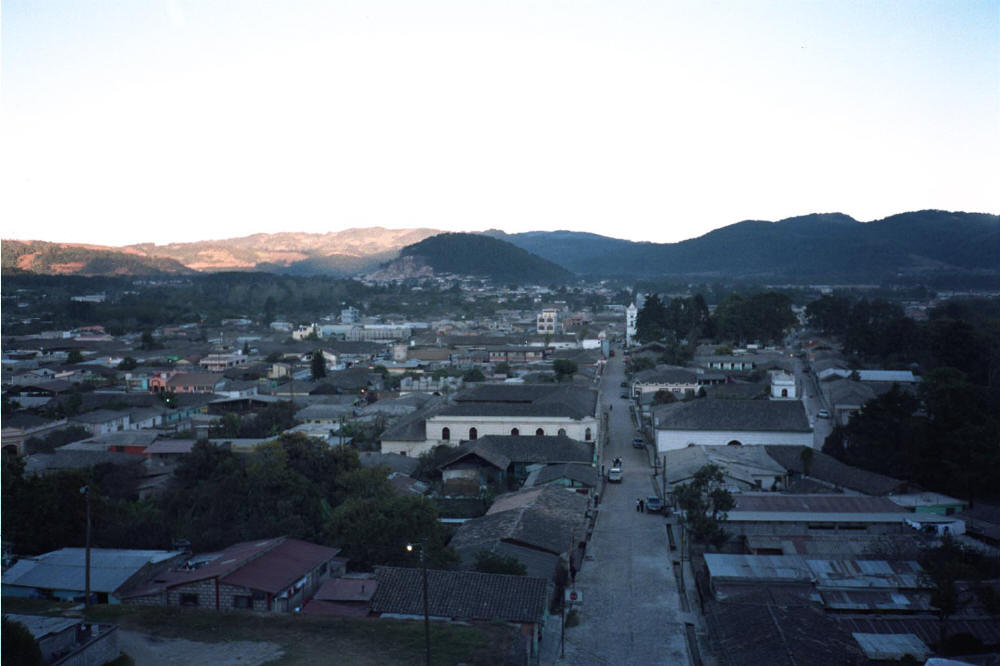
View from the Mirador

Around the park

Around the park
Honduras 2004
January 13- 18
I wrote a bit on this fascinating and beautiful place here. There are several parts to the park, only one of which I visited but plan on seeing the rest in April when I return from Costa Rica. The part I visited offered a two-level guard station where I was allowed to stay. I simply set my tent on the second floor. This station has three rooms and enough space for 8 persons to stay in comfort. The bathroom is almost done, and there will be a cooking facility. Below the house is an enclosed area for several more tents.
Pico Bonito is reached from La Ceiba. You can take a bus near the central park, but with a backpack it is a bit clumsy. I took a taxi for $7 that went to Armenia Bonito, where there are supplies but no fuel. From there is a clear track that goes into the park (2 hours). You will have to pay $6 per day, and around $8 a day if you need a guide. The river is 200 meters away from the house and one can have a refreshing bath after sweating all day in the humid climate. I returned to Armenio Bonito after four days and took the bus back to La Ceiba (1 hour).
Right now there are two trails from the guard house, one going to a mirador with fine views to La Ceiba (1-1.5 hours), the other roughly follows the river to one of the small dams that provide water to the villages near the park (3 hours). There are plans to create many other trails as well.
A machete is absolutely necessary here. There are many birds but few insects.
|
View from the Mirador |
Around the park |
Around the park |
![]()
February 8 - 14
This is probably the most developed national park in Honduras. One enters from the town of Gracias, which is around five hours from Tegucigalpa via La Esperanza, or two from Santa Rosa de Copan. From Gracias it is an 8 kilometer walk to the park entrance where one pays $3 to enter and $3 per day. It is money well spent. At the park headquarters there is a building for ten people to stay, good camping spaces and plentiful water. There are even toilets! All trails are well-marked with ribbons. It is impossible to get lost, even for me.
I camped one day there, and then took a day hike to the mirador to see the waterfalls. The trail to them, like the trail to both campsites, is straight up. I never saw the falls, alas, as the trail to them branched out from the main one and led far down to the viewpoint. I had gained too much hard-won altitude to lose it in a few minutes, so I just continued up to try and get close to the falls. This trail is off the main route and simply petered out after an hour or so.
The next day I walked four hours to the first campsite at Don Tomas, about 400 meters up and for the first two hours is the same one to the falls. There is good water there as well as a well-rusted out cabin of sorts. It is also colder at night than it was below. The next day I went up and up and up for two hours to the next campsite at Naranjo---2100 meters. It is in a marvelously thick forest with monkeys scampering through the trees. It is cold up there, so dress well! From Naranjo the summit of Celaque is five hours away round trip. It meanders more or less upwards until the peak at 2825 meters. From there is a trail that leads to Belén Gualcho two days away, but it is poorly marked and I do not recommend it.
The last day I walked all the way from Naranjo to Gracias---six hours and 900 meters straight down. My legs paid the price for a few days, but my stomach was rewarded with cold beer and good food a day sooner than expected---a good bargain I should think.
|
Resting an hour toward the first camp. |
The second camp, Naranjo. |
The first camp, Don Tomas. |
View from the park entrance toward Gracias. |
|
Gracias |
La Esperanza |
![]()
February 20 - February 25
This place is a tough one to call. It has no infrastructure whatsoever, the trail is in wretched condition---when it exists at all---and there is scarce water after leaving the river for the summit at La Picucha. All is muddy, with many ups and downs, there are many trees down on the way to the summit, and there are legions of bugs always about. What one sees here is what one sees in other Honduran parks that are not so poorly maintained. Hurricane Mitch really did a number here. So is it worth a visit?
In a word, yes. The river scenery is stunning for one thing, and the sense of accomplishment one gets from actually getting to the ridge without a guide---even if not getting to the summit of Picucha---is worthwhile indeed. There are also families of howler monkeys about.
One takes a bus to Juticalpa (three hours), then another one to Gualaco (two hours). While in Gualaco stop in at Codhefor office to get whatever information it has---not much, all things considered. From Gualco the park entrance is 11 kilometers away toward San Esteban. There is plenty of transport, though the road is not very good. The trail to the river is clear and mostly up, and the first campsite is right before the fine waterfalls about four hours in. You will have to cross the river about 14 times---yes, 14 times---but you will get there.
The next day the real fun begins. The "trail" to the ridge that leads to the second campsite---I never found this second one, and never found the water that was supposed to be there either---is horrible and at times invisible. It is three hours to the ridge with no let up in ascent, and from there---supposedly---there is a second campsite. I will have to take Codhefor's word on this, however. It is easy to get lost up there, and a machete is necessary. The summit is supposedly three hours from the second campsite, but as I found neither them nor any water up there I spent a very thirsty night camped on the ridge. Water came the next day after a three hour descent back to the first campsite.
The road to Gualaco was six hours away, as I took a different route back. Hitching was easy, and there is ample transport.
I would not do this hike again, but I am glad I did it---no, I am glad that I finished it!
|
River view one day into the park |
Waterfalls near the first camp site |
Trail leading toward Gualaco |
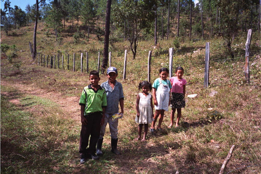
Children in the park |
|
Chilling' |
Trail in park |
River view near campsite |
Gualaco |
![]()
San Esteban - Dulce Nombre de Culmi
These two villages are at either side of the Sierra Agalta range in the state of Olancho. Both are rather hard to get to as it involves an uncomfortable and lengthy bus ride either way. I chose to bus to San Esteban from La Ceiba, a bone-rattling nine hour ride on a school bus. This little village is pleasant enough, but it has a violent recent history involving family feuds and more than 80 murders.
I stayed in the Hotel Centro, a charming family-run place. It claims that internet will soon arrive there. We will see. Anyway, the route to Dulce Nombre de Culmi is straightforward enough, but the first part---to the village of San Agustin---is under the fierce sun and follows a rough road suitable for 4-wheel drive only. One should hitch a ride rather than just walk and suffer. Near San Agustin there is plenty of private land to camp on and many streams, but try and ask the owner first. Remember to camp out of sight.
The next day head along the track to Malacate, the next stopping place. Here the trail becomes narrow and only for walkers or pack animals. The scenery changes as well as you enter the forest and begin the climb to the watershed between San Esteban and Culmi. There is much mud, and the route has been chopped up by beasts of burden. As you reach the ridge much deforestation is seen before dropping down to a valley near Malacate. There are many inhabitants here, and you would be safest to camp at some house after asking the owner for permission. There is much crime in this valley.
The next day will take you six hours to Culmi, an unpleasant village from which you will find daily transport to Catacamas and then on to Tegucigalpa.
This hike was not very fun, all was work and worry with no payoff in enjoyment. I do not recommend it.
I wrote this about the place here:
I returned two days ago from an unpleasant three-day hike from San Esteban to the village of Dulce Nombre de Culmi. It was unpleasant for a variety of reasons. For one thing, there was not much to see as I crossed the Sierra de Agalta mountains. Much of the land has been deforested and there was little shade---and it was blistering hot always and everywhere. The mule track between those two villages has been severely chopped up by beasts of burden, and the mud was the worst I had been in since Guatemala in December. There were armies of ticks scurrying through the dirt, and their attaching themselves to my flesh was a constant annoyance.
Of course, I have been through all of this and more many times. What really destroyed whatever enjoyment was to be had by walking through this part of rural Honduras was the ever-present threat of violence. I scarcely passed anyone who did not warn me of roaming gangs of thieves and killers lurking about in the hills and preying upon all and sundry. One man on horseback I ran into was armed with both pistol and shotgun---and he was afraid. He told me tales of thieves hiding off the trail who had robbed him twice. The man related how in the Honduran hills there is no law enforcement whatsoever, and so the law is defined by him who wields the most firepower. He absolutely refused to allow me to camp on a riverbed where I had set my tent and strongly insisted that I camp in his front yard. I was a bit spooked by then and so complied. Just how safe I was camped there was clear the next day. He pulled out his complete armory, which included a Chinese-built AK-47. I tell you, if any gangs raid his home they will get a faceful of bullets for sure.
I decided then and there that my plans to head north toward the Mosquito Coast were out of the question. Besides, there had been rain up north, which meant more oceans of mud---no thanks. To top things off, the village of Dulce Nombre de Culmi was borderline hostile. The people were indifferent and suspicious, and the "hotel" I stayed in was the worst I had seen, a truly ghastly place filled with insects, ancient filth, blocked plumbing---if that bizarre series of oozing pipes could be termed such---a terrible stench and shady characters. But wait, there is more: Because I arrived there on Passover Thursday, there would be no transport the next day, Holy Friday. So I was stuck in this pestilent s*** hole ( pardon the expletive, but I am in a foul mood) for two days. But wait, there is more: There were no places to eat in this damned place. I lived off beer and stale bread, and a dish of typical Honduran food that a woman agreed to make for me. Returning to Tegucigalpa was like crossing the Jordan River.
And I praise the Risen Lord for bringing me out of that forsaken spot.
Nothing more really to add. It is a shame, as it was the next hike after my nine-days spent in the Costa Rican jungles with some ex-Lincoln School students. This was one of the highlights of my backpacking career. Perhaps any place I went after that would have been a letdown.
|
The trail on the third day. |
Trail near Malacate. |
Farmhouse near San Agustin. |
Vista near San Agustin. |
![]()
Home Professional Pages Personal Pages Sabbatical Itinerary