Guatemala
2003 - 2004
The Mayan Ruins of Yaxha - Nakum - Tikal
December 16 -
December 22
My original plans were to hike between these ruins as a warm-up
to a longer walk through the jungle from Carmelita up north into the vast
forests of Guatemala's Petén. However, I miscalculated the rainy season, and so
much of my time walking between these ruins was spent with mud, rain and
mosquitoes. Not entirely fun, but it was a fine exercise in endurance! I
postponed the second part of this trip and will return in late April when the
dry season should be in full swing.
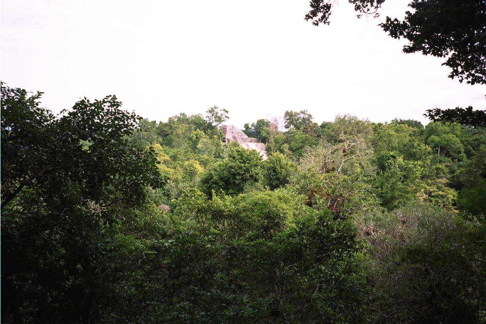
The Mayan ruins encountered on this hike are extraordinary. The
first is Yaxha, which looks to be the next Tikal. That is, in five years this
site will be as visited and as tourist-friendly as Tikal. So see it now.
This hike is demanding, as most of it is in pure jungle. You
will encounter xateros (gathers of xate) and their camps, and you should always ask for
the proper route. Once leaving Nakum there are several ways to get to Tikal, all
along rather obscure jungle trails. It is easy for even an experienced jungle
hiker (like me) to get lost. Be prepared for rain and bugs---and the occasional
mountain lion. This last advisory is a serious one: while I was in Guatemala a
worker was killed and eaten by a lion. See
here for details. There are
also crocodiles in the small lagoons en route. You will absolutely need both
machete and compass---without these you could come to grief. You will also
need an appropriate ING map available in Guatemala City: Tikal. It shows
half of Petén. And always carry two liters of water as it is a bit scarce in
places.
Do not be stupid. This hike is challenging and rewarding but
also dangerous, especially if going solo. Be prepared.
I spent six days in the area.
From Santa Elena---the sister village to Flores---take any micro
heading to Melchor de Menchos, the last stop in Guatemala before Belize. About
65 kilometers (one hour) you will come to the road that leads to Yaxha. It is 11
easy kilometers to the ruins. There you will find fine places to camp under
cover, and water, bathrooms and a shower! There are many workers there as well,
from whom you should get advice on the conditions of the road to Nakum. Be
advised that since Yaxha is easy to get to you will probably have some company
from other travelers and more than a few tourists.
Nakum is 20 kilometers away on a well-marked road that is
entirely impassable after a rain because of mud. Here there is also a good
campsite, but no tourists. The ruins are extensive, with some scarcely
excavated.
The tricky part of this walk is getting from Nakum to Tikal. The
workers have their own routes to Tikal that are entirely confusing unless you
manage to hire a worker as a guide. Using no guide it took me three days to get
to Tikal. The last day I walked 9 hours with map and compass in hand. The route
to Tikal is around 36 kilometers.
My route was as follows: Follow the same road that led to Nakum.
After 200 meters you will find a wide but muddy trail to the right. Take it for
two hours after which you will come to a major access road that leads from the
border of Tikal to the border with Belize. Turn left and after five hours you
will come to a camp of chicleros. Get advice from them about continuing.
The camp is half-way between Nakum and Tikal. You can make it in one long day
with a guide, two without. The official border of the park, however, is only 30
minutes away.
You will come to the outskirts of Tikal long before you get to
the major ruins. There are many unexcavated temples that have been looted by
robbers (huaqueros). If you run into some they will not appreciate your
company.
Tikal is due West, and cutting cross-country after the trail
peters out is not difficult with a machete and a compass. You will encounter
Tikal after 4 - 6 hours of cross-country walking.
Good luck, and be careful.
|

Yaxha
|

Yaxha |

Yaxha |

Yaxha |
|

Yaxha |

The road from Yaxha |

Temple I at Tikal |

Mud all the way to Nakum |
|

Nakum |

Nakum |

Nakum |

Nakum |
|

Nakum |

Nakum |

Cooking at xatero camp |

Xatero hut |
|
|

Xatero |
|
|

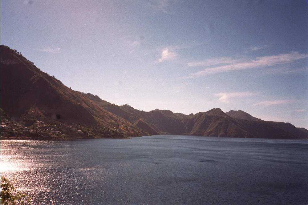
Lake Atitlán
December 28 -
January 5
Lake Atitlán is two hours from Antigua and well worth exploring. The usual
way is to stop at Panajachel ("Pana"), and go from there. My thoughts on the
place can be found
here---but do
not let these dissuade you. It was once a hippy magnet---the locals called it
Gringotenango ("the place where gringos are")---attracting all of the young
and hygienically challenged throughout the Western world. This crowd has mainly
fled to San Pedro across the lake---but more on these creatures in due course.
The best way to see the stunning visuals that the lake offers is to walk
around it, going from village to village. I did this almost, only stopping at
San Pedro from where I took a boat across the lake back to Pana. I wrote this
about why:
The
problem was that the further I moved around the lake, the more I ran into
Euro-trash hippy types. It
seems that they have slowly migrated from Panajachel to San Pedro and San
Marcos. These villages have developed a local
part---usually away from the lake---and a foreign part filled with the tattooed,
the pierced, the scantily attired,
the doped-up and dropped-out, the bra-less and law-less,
the shirt-less and worthless, the
clueless and the shoe-less. It is bad enough that I must
witness this motley and malodorous throng on
the streets of my home town of Portland, at Dean for President rallies
and at Greenpeace reunions
but I refuse to share my vacation with them.
The next town on the
route around the lake, San Marcos, was rumored to be even worse than San Pedro.
Thus, my exit.
I slowly traveled East,
and stayed at Indigenous villages where there was always at least a
hospedaje. Thus, tent, stove and all the other accutrements of backpacking
were left behind. It was odd at first not having my pack weigh as much as a
well-fed teenager, but I got used to it quickly. Some of the villages are
delightful, especially San Lucas where there was Internet access, fine food and
a dearth of the hippy types. The locals mainly wear traditional clothing.
You can walk near the
lake for much of the time, but private property has claimed some of the shore,
forcing you to the road. Hitching is easy but you will have to pay. There are
many connecting paths between the villages. Ask the locals, they know them.
The photos below were
taken from a variety of vantage points around the lake.
Home
Professional Pages
Personal
Pages
Sabbatical
Itinerary
Essays
Backpacking
Entries
Diary
and Commentary
Search
E-Mail